

Weekend Weather Alert: Potential Storms in Dallas-Fort Worth
Saturday Outlook: Late Evening Storm Risks
The weather forecast for Saturday indicates the presence of low clouds in the morning, attributed to moisture being drawn in from the Gulf by southerly winds.
As the day progresses, expect these clouds to dissipate, allowing sunlight to return around noon. Temperatures are anticipated to rise into the 80s, accompanied by gusty winds reaching speeds of 25 to 30 miles per hour. However, due to a strong temperature cap, severe storm development throughout the afternoon is not expected.
As evening approaches, the risk for storms increases due to a dry line approaching from the west paired with a significant atmospheric disturbance that may break the cap. If storms form, they are likely to develop between 8 PM and 1 AM, primarily affecting areas to the west and north of the DFW region, posing risks of hail and high winds.
Residents are advised to utilize garages for vehicle protection during this period, just in case storm activity escalates.
Live Weather Radar

Sunday Forecast: Morning and Evening Storm Possibilities
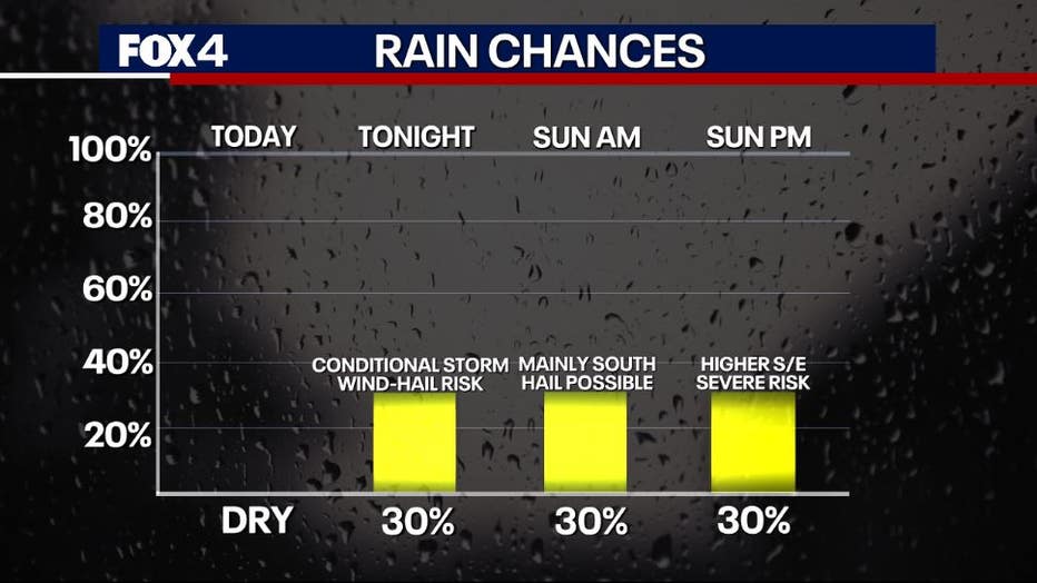
On Sunday, a new atmospheric disturbance is expected to make its way from the hill country in the early morning hours, bringing a 20-30% chance of isolated storm activity. Although coverage may be limited, there remains a risk of hail.
After any potential morning storms, temperatures will rebound into the 80s before a cold front approaches from Oklahoma in the late afternoon. This front is anticipated to trigger a line of storms primarily from Dallas eastward between approximately 4 PM and 10 PM. The potential for severe weather, including hail and high winds, will accompany these storms, which are expected to be scattered.
Overall, while widespread storms are not likely, those that do materialize have a potential for severity.
Severe Weather Outlook: 7-Day Forecast

The forecasts also suggest that storm chances may return as the week progresses, with more potential weather systems moving into the area.
