Introduction
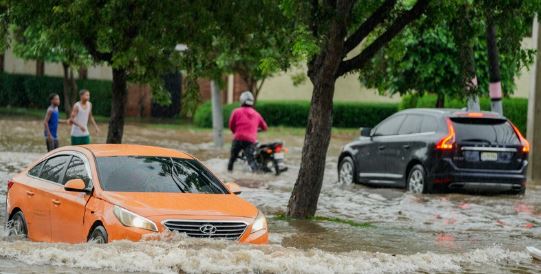
In August 2022, the Dallas-Fort Worth area experienced one of the most intense rain events in its recorded history. Over a 24-hour span, some neighborhoods received more than 13 inches of rain — more than the region typically sees in an entire summer month. The result was catastrophic flash flooding, with overwhelmed infrastructure, stranded vehicles, and emergency water rescues making national headlines.
But what exactly caused this historic rainfall? And with climate extremes becoming more frequent, could a storm like this strike again?
The Meteorological Setup: Why the Storm Was So Extreme
The storm system that swept through North Texas on August 21–22, 2022, was fueled by a unique combination of atmospheric conditions:
- Stalled Weather Pattern: A slow-moving low-pressure system pulled in tropical moisture and stalled over the region.
- Warm Ground and High Humidity: August’s typical heat and moisture acted like fuel, intensifying rainfall rates.
- Urbanization Impact: The heavily paved Dallas-Fort Worth metroplex is prone to rapid runoff, which worsens flash flooding during intense storms.
According to the National Weather Service, this was a 1-in-1000-year rain event for some localized areas.
Impacts on Communities: From Highways to Homes
The flooding overwhelmed both natural waterways and man-made infrastructure. Key effects included:
- Transportation Chaos: Major highways, including Interstate 30 and Interstate 45, turned into rivers. Hundreds of cars were submerged or abandoned.
- Emergency Rescues: First responders carried out more than 200 water rescues in a single day, including dramatic rooftop evacuations.
- Property Damage: Homes and businesses across Dallas, Mesquite, and surrounding towns suffered water damage. Some structures were declared uninhabitable.
One woman tragically lost her life after her vehicle was swept away, underscoring the deadly nature of flash floods.
Climate Change and Urban Growth: A Risk Multiplier?
Experts say the August 2022 flood reflects broader climate risks facing urban areas in Texas and beyond:
- More Frequent Extremes: Warmer air holds more moisture, increasing the odds of sudden downpours. According to NOAA, heavy rainfall events in the Southern Plains have risen significantly in recent decades.
- Urban Development Pressure: As cities expand, impervious surfaces increase runoff, while older drainage systems often remain unchanged.
“Dallas is not unique in this,” said Dr. Katharine Hayhoe, climate scientist and Texas Tech professor. “Many cities are playing catch-up as the climate shifts faster than infrastructure.”
Lessons Learned: Can Dallas Be Better Prepared?
In the wake of the disaster, local officials and engineers began reevaluating flood response plans:
- Upgrading Drainage Systems: Dallas Water Utilities has fast-tracked improvements in low-lying flood-prone neighborhoods.
- Early Warning Systems: Investments in real-time flood monitoring and alerts aim to give residents more lead time.
- Green Infrastructure: Projects such as rain gardens and permeable pavement are being considered to better absorb stormwater.
What Residents Can Do: Preparedness Tips That Save Lives
Flash floods can happen with little warning. Here’s how individuals can stay safe:
- Stay Weather-Aware: Use NOAA alerts and local emergency apps during storm season.
- Avoid Flooded Roads: “Turn around, don’t drown” isn’t just a slogan — most flood deaths occur in vehicles.
- Check Flood Insurance: Standard homeowners insurance often doesn’t cover flood damage; check your policy details annually.

